OFFICIAL
DESCRIPTION CHANGE
OFFICE:
Transportation Data
EFFECTIVE DATE: 11-6-08
ENTERED
BY: Darlene Bovee
ENTERED DATE: 12-05-08
New
Description ‑
Beginning
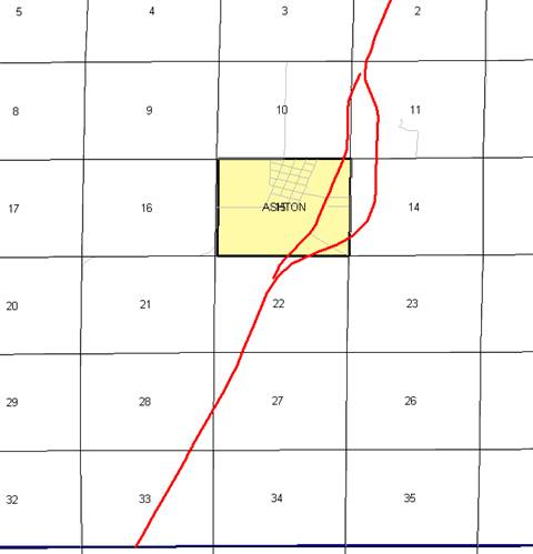
on the Osceola‑O'Brien County line at a point near the S ¼ Corner of
Section 33‑T98N‑R42W, Osceola County (N ¼ Corner of Section 4‑T97N‑R42W,
O'Brien County); thence northeasterly through Sections 33, 28, 27 and 22‑T98N‑R42W
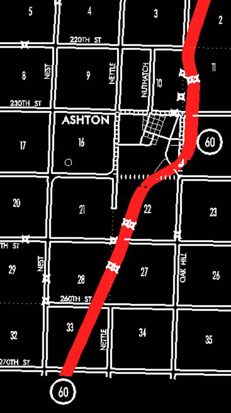
to the south corporation line of Ashton, connecting with an unnamed street
(approximately 1580 feet west of the SE Corner of Section 15-T98N-R42W).
Ashton:
Beginning
on an unnamed street at the south corporation line; thence northeast on unnamed
street to the east corporation line (approximately 980 feet north of the SE
Corner Section 15‑T98N‑R42W).
Beginning
again on the east corporation line of Ashton, connecting with an unnamed
street; thence northeasterly, northerly, and northwesterly through Section 14
and 11‑T98N‑R42W to a point approximately 610 feet east of the NW
Corner of said Section 11; thence northeasterly through Section 2‑T98N‑R42W
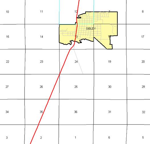
and Sections 35, 26, 25 and 24‑T99N‑R42W to a point approximately
1890 feet south of the NE Corner of said Section 24-T99N-R42W; thence easterly
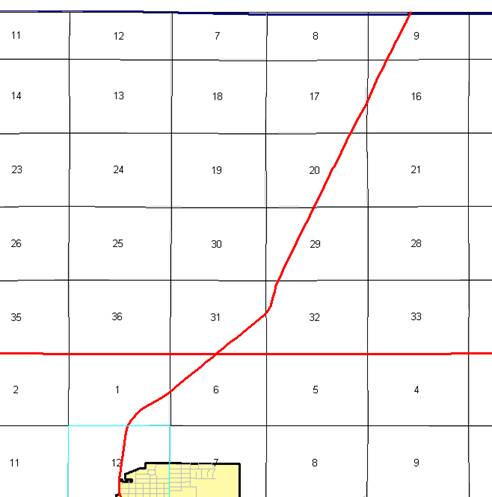
and northeasterly and northerly through Sections 19, 20, 17, 8 and 5-T99N-R41W to a point near the
N ¼ of Corner Section 5-T99N-R41W; thence northerly following substantially the
center section line of Sections 32 and 29-T100N-R41W to a point approximately
100 feet east of the N ¼ Corner of Section 29-T100N-R41W; thence northeasterly
through Sections 20, 17, 16 and 9-T100N-R41W to the Iowa-Minnesota State line
at a point near the NE Corner of Section
9-T100N-R41W, Osceola County, Iowa.
OFFICIAL
DESCRIPTION CHANGE
OFFICE:
Transportation Data
EFFECTIVE DATE: 11-29-07
ENTERED
BY: Darlene Bovee
ENTERED DATE: 12-07-07
New
Description ‑
Beginning
on the Osceola‑O'Brien County line at a point near the S ¼ Corner of
Section 33‑T98N‑R42W, Osceola County (N ¼ Corner of Section 4‑T97N‑R42W,
O'Brien County); thence northeasterly through Sections 33, 28, 27 and 22‑T98N‑R42W
to the south corporation line of Ashton, connecting with an unnamed street
(approximately 1580 feet west of the SE Corner of Section 15-T98N-R42W).
Ashton:
Beginning
on an unnamed street at the south corporation line; thence northeast on unnamed
street to the east corporation line (approximately 980 feet north of the SE
Corner Section 15‑T98N‑R42W).
Beginning
again on the east corporation line of Ashton, connecting with an unnamed
street; thence northeasterly, northerly, and northwesterly through Section 14
and 11‑T98N‑R42W to a point approximately 610 feet east of the NW
Corner of said Section 11; thence northeasterly through Section 2‑T98N‑R42W
and Sections 35, 26, 25 and 24‑T99N‑R42W to a point approximately
1890 feet south of the NE Corner of said Section 24-T99N-R42W; thence easterly
and northeasterly and northerly through Sections 19, 20, 17, 8 and 5-T99N-R41W to a point near the
N ¼ of Corner Section 5-T99N-R41W; thence northerly following substantially the
center section line of Sections 32 and 29-T100N-R41W to a point approximately
100 feet east of the N ¼ Corner of Section 29-T100N-R41W; thence northeasterly
through Sections 20, 17, 16 and 9-T100N-R41W to the Iowa-Minnesota State line
at a point approximately 3,000 feet west of the NE Corner of Section
9-T100N-R41W, Osceola County, Iowa.
OFFICIAL
DESCRIPTION CHANGE
OFFICE:
Transportation Data
EFFECTIVE DATE: 01-10-2006
ENTERED
BY: Stefani Wonders
ENTERED DATE: 09-06-2006
New
Description ‑
Beginning
on the Osceola‑O'Brien County line at a point on the east side of the
Chicago and Northwestern Railway, approximately 500 feet west of the S ¼ Corner
of Section 33‑T98N‑R42W, Osceola County (N ¼ Corner Section 4‑T97N‑R42W,
O'Brien County); thence northeasterly along the east side of said railroad and
substantially parallel thereto, through Sections 33, 28, 27 and 22‑T98N‑R42W
to the south corporation line of Ashton, connecting with an unnamed street
(approximately 2175 feet west of the SE Corner of said Section 22).
Ashton:
Beginning
on an unnamed street at the south corporation line; thence northeast on unnamed
street to the north corporation line (approximately 968 feet north of the SE
Corner Section 22‑T98N‑R42W).
Beginning
again on the north corporation line of Ashton, connecting with an unnamed
street; thence northeasterly, northerly, and northwesterly through Section 14
and 11‑T98N‑R42W to a point approximately 822 feet east of the NW
Corner of said Section 11; thence northeasterly along the east side of said
railroad and substantially parallel thereto through Section 2‑T98N‑R42W
and Sections 35, 26, 25 and 24‑T99N‑R42W to a point approximately
1,000 feet west of the N ¼ Corner Section 24‑T99N‑R42W; thence
northeasterly and northerly through Section 13‑T99N‑R42W to the
south corporation line of Sibley, connecting with 2nd Avenue (approximately
1705 feet north and 3294 feet east of the SW Corner of said Section 13).
Sibley:
Beginning on
Beginning
again on the north corporation line of Sibley connecting with 2nd Avenue;
thence northerly and northeasterly along the east side of the Chicago and
Northwestern Railway and substantially parallel thereto through Sections 12 and
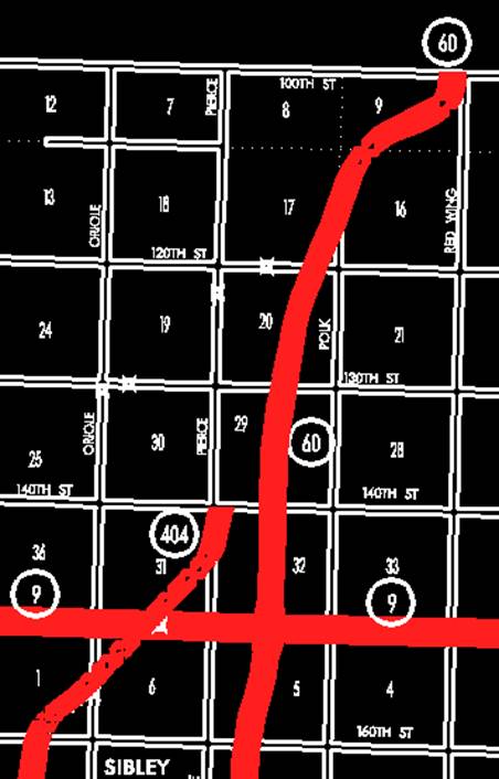
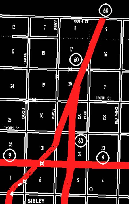
1‑T99N‑R42W and 6‑T99N‑R41W to a point (junction Iowa 9)
approximately 2,430 feet east of the NW Corner Section 6‑T99N‑R41W;
thence northeasterly along the east side of the Chicago and Northwestern
Railway and substantially parallel thereto through Sections 31, 32, 29, 20, 17,
16 and 9‑T100N‑R41W to the Iowa‑Minnesota State line at a
point approximately 3,000 feet west of the NE Corner of Section 9‑T100N‑R41W,
Osceola County, Iowa.
OFFICIAL
DESCRIPTION CHANGE
COUNTY: Osceola
ROUTE:
STAFF
ACTION NUMBER:
S-87-1523
APPROVAL
DATE: 5-13-87
New
Description ‑
Beginning
on the Osceola‑O'Brien County line at a point on the east side of the
Chicago and Northwestern Railway, approximately 500 feet west of the S ¼ Corner
of Section 33‑T98N‑R42W, Osceola County (N ¼ Corner Section 4‑T97N‑R42W,
O'Brien County); thence northeast along the east side of said railroad and
substantially parallel thereto, through Sections 33, 28, 27 and 22‑T98N‑R42W
to the south corporation line of Ashton, connecting with an unnamed street.
Ashton:
Beginning
on an unnamed street at the south corporation line; thence northeast on unnamed
street to the north corporation line.
Beginning
again on the north corporation line of Ashton, connecting with an unnamed street;
thence northeast and north through the east part of Section 10‑T98N‑R42W
to a point on the east side of the Chicago and Northwestern Railway
approximately 200 feet west of the E ¼ Corner Section 10‑T98N‑R42W;
thence northeast along the east side of said railroad and substantially
parallel thereto through Sections 10, 11 and 2‑T98N‑R42W and
Sections 35, 26, 25 and 24‑T99N‑R42W to a point approximately 1,000
feet west of the N ¼ Corner Section 24‑T99N‑R42W; thence northeast
and north through Section 13‑T99N‑R42W to the south corporation
line of Sibley, connecting with 2nd Avenue.
Sibley:
Beginning on
Beginning
again on the north corporation line of Sibley connecting with 2nd Avenue;
thence north and northeast along the east side of the Chicago and Northwestern
Railway and substantially parallel thereto through Sections 12 and 1‑T99N‑R42W
and 6‑T99N‑R41W to a point (junction Iowa 9) approximately 2,430
feet east of the NW Corner Section 6‑T99N‑R41W; thence northeast
along the east side of the Chicago and Northwestern Railway and substantially
parallel thereto through Sections 31, 32, 29, 20, 17, 16 and 9‑T100N‑R41W
to the Iowa‑Minnesota State line at a point approximately 3,000 feet west
of the NE Corner of Section 9‑T100N‑R41W, Osceola County, Iowa.
COMMISSION
ORDER
DIVISION:
Planning & Research
COMMISSION
ORDER NUMBER:
PR-79-272
SUBMITTED
BY: C.I. MacGillivray
MEETING
DATE: 11-2-78
DISCUSSION/BACKGROUND:
Due
to a renew of our Primary Road System records, Iowa 60 in Osceola County should
be deleted and the new description added should be officially included into the
Primary System.
Iowa
60 begins on the Osceola‑O'Brien County line approximately 2 ½ miles east
of the SW Corner of Osceola County, and travels northeasterly via Ashton and
Sibley to the Iowa‑Minnesota State line approximately 8 ½ miles east of the NW Corner of Osceola
County, Iowa at Bigelow, Minnesota.
PROPOSAL/ACTION
RECOMMENDATION:
Locate
Beginning on the Osceola‑O'Brien County line at a
point on the east side of the Chicago & Northwestern Railway, approximately
500 feet west of the S ¼ Corner of Section 33‑T93N‑R42W, Osceola
County (N ¼ Corner Section 4‑T97N‑R42W, O'Brien County); thence in
a northeasterly direction along the east side of said railroad and
substantially parallel thereto, through Sections 33, 28, 27 and 22‑T98N‑R42W
to the south corporation line of the City of Ashton connecting with an unnamed
street.
Ashton:
Beginning on
the south corporation line connecting with an unnamed street; thence
northeasterly to the north corporation line connecting with an unnamed street.
Beginning again on the north corporation line of the
City of Ashton, connecting with an unnamed street; thence in a northeasterly
and northerly direction through the east part of Section 10‑T93N‑R42W
to a point on the east side of the Chicago and Northwestern Railway,
approximately 200 feet west of the E ¼ Corner Section 10‑T98N‑R42W;
thence in a northeasterly direction along the east side of said railroad and
substantially parallel thereto through Sections 10, 11 and 2‑T98N‑R42W
and Sections 35, 26, 25 and 24‑T99N‑R42W, to a point approximately
1000 feet west of the N ¼ Corner Section 24‑T99N‑R42W; thence in a
northeasterly and northerly direction through Section 13‑T99N‑R42W
to the south corporation line of the City of Sibley, connecting with an unnamed
street.
Sibley:
Beginning on the south corporation line connecting with
an unnamed street; thence northerly to the north corporation line connecting
with an unnamed street.
Beginning again on the north corporation line of the
City of Sibley connecting with an unnamed street; thence in a northerly and
northeasterly direction along the east side of the Chicago and Northwestern
Railway and substantially parallel thereto through Sections 12 and 1‑T99N‑R42W
and 6‑T99N‑R41W to a point (junction Iowa 9) approximately 2430
feet east of the NW Corner Section 6‑T99N‑R41W; thence in a northeasterly
direction along the east side of the Chicago and Northwestern Railway and
substantially parallel thereto through Sections 31, 32, 29, 20, 17, 16 and 9‑T100N-R41W
to the Iowa‑Minnesota state line at a point approximately 3000 feet west
of the NE Corner of Section 9‑T100N‑R41W, Osceola County, Iowa.
NOW, THEREFORE: Be it resolved that the Iowa Department
of Transportation approve the location of
NOTE: To become effective noon the adoption of this
resolution.
REVISED: 5-13-87
OFFICIAL
DESCRIPTION CHANGE
COUNTY: Osceola
ROUTE:
APPROVAL
DATE: 12-31-68
Beginning
on the Osceola‑O'Brien County line at a point on the east side of the
Chicago and Northwestern Railway, approximately 500 feet west of the S ¼ Corner
of Section 33-T98N‑R42W, Osceola County (N ¼ Corner Section 4‑T97N‑R42W,
O'Brien County); thence in a northeasterly direction along the east side of
said railroad and substantially parallel thereto, through Section 33, 28, 27
and 22‑T98N‑R42W to the south corporation line of the Town of
Ashton connecting with an unnamed street.
Ashton:
Beginning
on unnamed street at the south corporation line; thence northeasterly on
unnamed street to the north corporation line.
Beginning
again on the north corporation line of the Town of Ashton, connecting with an
unnamed street; thence in a northeasterly and northerly direction through the
east part of Section 10-T98N‑R42W to a point on the east side of the
Chicago Northwestern Railway, approximately 200 feet west of the E ¼ Corner
Section 10‑T98N‑R42W; thence in a northeasterly direction along the
east side of said railroad and substantially parallel thereto through Section
10, 11, and 2‑T98N‑R42W and Section 35, 26 and 24‑T99N‑R42W
to a point approximately 1000 feet west of the N ¼ Corner Section 24-T99N-R42W;
thence in a northeasterly and northerly direction through Section 13‑T99N‑R42W
to the south corporation line of the Town of Sibley, connecting with Second
Avenue.
Sibley:
Beginning on
Beginning again on the north corporation line of the Town
of Sibley, connecting with Second Avenue; thence in a northerly and
northeasterly direction along the east side of the Chicago and Northwestern
Railway and substantially parallel thereto through Section 12 and 1-T99N‑R42W,
Section 6‑T99N‑R41W and Section 31, 32, 29, 20, 17, 16 and 9‑T100N‑R41W
to the Minnesota State line at a point approximately 3000 feet west of the NE
Corner of Section 9‑T100N‑R41W.
REVISED: 11-2-78